kuepper
Well-known member
Again how did you find that - what do you mean 'someone on Ancestry'? Sorry for all the Qs but I'm new to this!Someone on Ancestry thinks its Upper Albion Street
View attachment 61717

Again how did you find that - what do you mean 'someone on Ancestry'? Sorry for all the Qs but I'm new to this!Someone on Ancestry thinks its Upper Albion Street
View attachment 61717
Its as Craggyjohn wrote up thread. When you're looking at an image of a census you can click on right & left arrows on either side of the page to move to the previous or next page. There's also a page number box at the bottom of the page that lets you jump to any page in the enumeration district. Its been a while since I spent much time on ancestry so I can't remember how the hints on other trees works.I've only just started on the family tree and still getting to know the Ancestry site so I didn't know how to find that. One thing I'm puzzled by is when you search for X and the result starts off saying they're in someone's family tree. You follow the link to that tree how do you find X when the tree is full of ppl you've never heard of, do you have click on every name til you find X?
You can search for a name in any treeI've only just started on the family tree and still getting to know the Ancestry site so I didn't know how to find that. One thing I'm puzzled by is when you search for X and the result starts off saying they're in someone's family tree. You follow the link to that tree how do you find X when the tree is full of ppl you've never heard of, do you have click on every name til you find X?
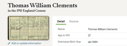
If you see something on Ancestry that has been incorrectly transcribed you can enter an alternative. When I looked at the image of the 1911 census there was a yellow box over the address and moving the mouse onto it opened the note/correction that someone had entered. The image below is taken form the ancestry search results page. If you click on the 'Add or update information' link shown just below the image of the 1911 census form you can enter various pieces of information.Again how did you find that - what do you mean 'someone on Ancestry'? Sorry for all the Qs but I'm new to this!
I appreciate its almost illegibleThere’s something to be appreciated about old style calligraphy, it’s almost a lost art. My own handwriting is simple, solid block capitals, usually scrawled out in crayola.
Even in the 60's South Bank was a thriving community and you could buy anything from the numerous shops it had on Nelson Street and Middlesbrough Rd. There was no need to go to the town to a specialist shop, South Bank had them.There is old map of South Bank on the facebook page of Slaggy Island memories.
My mam says South Bank was a bit of a special place in the 1940s and 50s. It was always had the feel of a different age to me - vintage cars, steam trains, picture houses, flat caps, woodbines.
He could have literally sold sand to the Arabs.Smollans

NC - Family members talked about Nelson Street - but I can't remember it - just flattened land. I remember my granny looking at road grates to work out where she had lived for over 25 years after she got married. Ity was like someone had dropped a nuclear bomb on that part of South Bank.Even in the 60's South Bank was a thriving community and you could buy anything from the numerous shops it had on Nelson Street and Middlesbrough Rd. There was no need to go to the town to a specialist shop, South Bank had them.
St Peters Social Club?FYI Albion Street was divided into two. Lower Albion Street stretched from Nelson Street to Middlesbrough Road. Upper Albion Street stretched from Middlesbrough Road to Redcar Road.
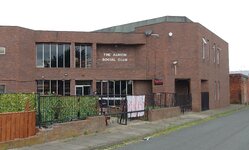
The Albion Club was on Lower Albion Street, but that street was demolished to make way for the A66. The Albion Club relocated to Henry Street. It's still there today, and it's the only remaining social club in South Bank. There used to be seven of them. There are no pubs left in South Bank. There used to be twelve.
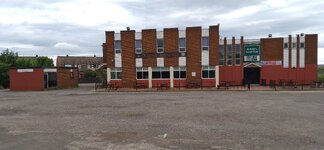
My bad - I've just looked at their FB, and St Peters is still just hanging on. They open a few days a week I think. I took a photo of it a few weeks ago and it was deserted, so I assumed that it had gone. No bookies there now thoughSt Peters Social Club?
I thought the St Peter’s Club was still open?FYI Albion Street was divided into two. Lower Albion Street stretched from Nelson Street to Middlesbrough Road. Upper Albion Street stretched from Middlesbrough Road to Redcar Road.
The Albion Club was on Lower Albion Street, but that street was demolished to make way for the A66. The Albion Club relocated to Henry Street. It's still there today, and it's the only remaining social club in South Bank. There used to be seven of them. There are no pubs left in South Bank. There used to be twelve.