Exploring Eston Mines

I always seem to remember the SS Castle being bigger than it is and having more areas to explore. I couldn't find the pump house closer to the old reservoir near the Normanby side but that use to always stink of pee when I was a kid and hated going near it.
 
The second picture is taken between the metal grating and shows a drop down to the ground. Could have done with having my head torch with me. The fourth picture shows the entrance at the back which was open but I chose not to go in any further with having the dog with me.

View attachment 55411View attachment 55410View attachment 55412View attachment 55413View attachment 55414
Awsome pictures - For someone not familliar with the area where would i drive to, to start this walk and is a loop or walk so far and turn back? Suitable for 6 and 3 year old walking?

Love the addition of the burn out car
 
Awsome pictures - For someone not familliar with the area where would i drive to, to start this walk and is a loop or walk so far and turn back? Suitable for 6 and 3 year old walking?

Love the addition of the burn out car
I started the walk in Normanby and headed up towards the old teacher's training centre - This is across the road from the Flatt’s Lane Country Park and has plenty of parking. I then followed the path from the road which runs along the bottom of the hills rising to just below the midway point. I followed this until I came to the mine workings at the top of California Bank. The climb was easy but the going was very muddy with large puddles due to the weather and the damage being done by the off road motorbikes. I think a three year old would struggle or need to be carried.

The path from here is heading in the same direction keeping the Nab on your right hand side. This path again was muddy but not as bad as the previous path and the S S Castle is around a mile form the first opening.

You also could go from Eston and climb up California Bank and again, I don't think the 3 year old could do this. This is the route I came back and passes the old miner's cottages - I use to live in one of these and only came that way to be nosy.

This route is shorter and the one I would suggest you take - To start here (and a lot less muddy) you would need to park in the street on either California Rd or on Old Row with the latter being closer to your route. You would then need to walk to the end of Old Row towards the A174 and pick up the path at the end of the terrace on your left hand side. Follow this path under the A174 and climb the hill. This path is steep for a six year old but with adequate stops, he should make it - I use to run up it when I was boxing. At the top of the path you should come to the first two pictures and then the opening of the mine. From there follow the path keeping the Nab on your right hand side.

There is also another route from Lazenby but I am not sure about this.
 
Ha, remember driving off road fire appliances up past the ss castle, then the hierarchi boughtvan appliance that was too big to fit under the bridge😳, lions led by donkeys springs to mind, the burnt out car brings back lots of smokey memories🙈
 
Reminds me of mountain biking up there when I lived in Nunthorpe. I'd go over the hills from the top of Ormesby Bank to Flatts Lane then up Pig Bank, past the Sheepwash, and along the top to the Nab. Then I'd do a loop round the back of the hills towards The Cross Keys and back to the top of Pig Bank passing what looked like an old orchard then back to the Nab again. This time I'd drop down towards Lackenby and the golf course (nice bit of single track of not too muddy) and pop out near the SS Castle. From there it was a along the old railway line (under the bridge you photographed) to the top of Cally Bank before braving the mud to head past the Elephant's **** and disused ski slope back to Flatts Lane, over the road and past the brickworks back to Swan's Corner and home again.

Very nostalgic typing all that!
The way you came back (elephant's @rse) is the way that I walked to Cali Bank. Also, did you mean Lazenby and not Lackenby?

Lackenby is the row of houses between Whale Hill and Lazenby. When I was about 12, there was a shop in the centre of that row of houses and we would call in there to get our provisions(sweets and pop) to walk up to Concker Wood and the S S Castle. It always seemed miles away.
 
Thanks - might have a mooch over Easter. Was recommended to start at the woodland park on Flatts Lane
 
I started the walk in Normanby and headed up towards the old teacher's training centre - This is across the road from the Flatt’s Lane Country Park and has plenty of parking. I then followed the path from the road which runs along the bottom of the hills rising to just below the midway point. I followed this until I came to the mine workings at the top of California Bank. The climb was easy but the going was very muddy with large puddles due to the weather and the damage being done by the off road motorbikes. I think a three year old would struggle or need to be carried.

The path from here is heading in the same direction keeping the Nab on your right hand side. This path again was muddy but not as bad as the previous path and the S S Castle is around a mile form the first opening.

You also could go from Eston and climb up California Bank and again, I don't think the 3 year old could do this. This is the route I came back and passes the old miner's cottages - I use to live in one of these and only came that way to be nosy.

This route is shorter and the one I would suggest you take - To start here (and a lot less muddy) you would need to park in the street on either California Rd or on Old Row with the latter being closer to your route. You would then need to walk to the end of Old Row towards the A174 and pick up the path at the end of the terrace on your left hand side. Follow this path under the A174 and climb the hill. This path is steep for a six year old but with adequate stops, he should make it - I use to run up it when I was boxing. At the top of the path you should come to the first two pictures and then the opening of the mine. From there follow the path keeping the Nab on your right hand side.

There is also another route from Lazenby but I am not sure about this.
Gonna have an explore over Easter with the kids, i reckon parking up on Old Row and having a walk over from there sounds the most straight forward. Never been up the Nab or round to the ruins of the old mines and always fancied it, so see how we get on
 
Gonna have an explore over Easter with the kids, i reckon parking up on Old Row and having a walk over from there sounds the most straight forward. Never been up the Nab or round to the ruins of the old mines and always fancied it, so see how we get on
There are a couple of trees blown down over Cali Bank but easy enough for anyone to get around. Just have a look on Google maps or another mapping service and you will see the direction of the path under the Parkway.

The route from Flatt's Lane is full of large ruts and deep puddles which I think kids would struggle with and is not worth the hassle.

My job this morning is to clean my boots and hose down my spats, they are thick with mud and are presently languishing in the greenhouse.
Yeah ive just looked at it - with your instructions - fairly straight forward even for a dimwit like me so thanks for that. My 2 are 11 and 13, fit kids quite active and they regularly storm Roseberry topping leaving me behind so they'll be sound with the terrain, its me getting them lost and needing the thunderbirds to come airlift us out at midnight that i'm worried about :ROFLMAO:
 
Yeah ive just looked at it - with your instructions - fairly straight forward even for a dimwit like me so thanks for that. My 2 are 11 and 13, fit kids quite active and they regularly storm Roseberry topping leaving me behind so they'll be sound with the terrain, its me getting them lost and needing the thunderbirds to come airlift us out at midnight that i'm worried about :ROFLMAO:
11 & 13! They should be doing the Flatt's Lane route. 🤣 🤣 🤣
 
Yeah ive just looked at it - with your instructions - fairly straight forward even for a dimwit like me so thanks for that. My 2 are 11 and 13, fit kids quite active and they regularly storm Roseberry topping leaving me behind so they'll be sound with the terrain, its me getting them lost and needing the thunderbirds to come airlift us out at midnight that i'm worried about :ROFLMAO:
So long as you keep the height of the hills on your right as you walk seawards, and you have trees about you rather than fields you won't go far wrong.
 
We regularly go up to the North Yorkshire Moors for a walk above Rosedale Abbey (or via Hutton Le Hole) and our starting point is the old iron works which is simply fascinating. I'm not sure if there is any access to the old mine itself but to stand outside and imagine what it was like as a working mine is wonderful. There is of course the remnant of the old railway line too which I believe went to Whitby.

After a long walk we always finish at The Coach House inn in Rosedale Abbey itself which serves brilliant pies.

There is another great walk close by in woods which is a secret, you would have to kill me before I reveal this.

1680166904488.png
 
The way you came back (elephant's @rse) is the way that I walked to Cali Bank. Also, did you mean Lazenby and not Lackenby?

Lackenby is the row of houses between Whale Hill and Lazenby. When I was about 12, there was a shop in the centre of that row of houses and we would call in there to get our provisions(sweets and pop) to walk up to Concker Wood and the S S Castle. It always seemed miles away.
Yes, Lazenby!
 
We regularly go up to the North Yorkshire Moors for a walk above Rosedale Abbey (or via Hutton Le Hole) and our starting point is the old iron works which is simply fascinating. I'm not sure if there is any access to the old mine itself but to stand outside and imagine what it was like as a working mine is wonderful. There is of course the remnant of the old railway line too which I believe went to Whitby.

After a long walk we always finish at The Coach House inn in Rosedale Abbey itself which serves brilliant pies.

There is another great walk close by in woods which is a secret, you would have to kill me before I reveal this.

View attachment 55434
Rosedale Loop, a nice beginner mountain bike ride. I used to take my kids here around here, then into the village for scones!
 
We regularly go up to the North Yorkshire Moors for a walk above Rosedale Abbey (or via Hutton Le Hole) and our starting point is the old iron works which is simply fascinating. I'm not sure if there is any access to the old mine itself but to stand outside and imagine what it was like as a working mine is wonderful. There is of course the remnant of the old railway line too which I believe went to Whitby.

After a long walk we always finish at The Coach House inn in Rosedale Abbey itself which serves brilliant pies.

There is another great walk close by in woods which is a secret, you would have to kill me before I reveal this.

View attachment 55434
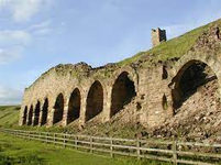
The Rosedale railway was there to transport the iron ore (partiallly extracted by the kilns at Rosedale) down to Battersby junction (and then on into M'boro). It had a big height difference which was "sorted" by the Ingleby Incline which was a 1:5 hill, where the weight of full trucks coming down hauled the empty trucks back up.

There were also Iron mines in Glaisdale dale. The old workings are full of water an provide spring water for the farms up there, The raw ore from there was transported down to the village where the furnaces were. There is an old railway line on the Glaisdale moor top. Whether this was used to transport ore down to the village (there is a big height differential between the moor and village), where the furnace were by the railway, via a similar "incline set up" I'm not sure. They may be the remains of Paddie Waddles railway which was a project to link the Glaisdale Mines to Lingdale / Moorsholm mines that had a lot of cuttings and bridges built but was never completed.

Thank you, I love reading stuff like this.
 
Back
Top