You are using an out of date browser. It may not display this or other websites correctly.
You should upgrade or use an alternative browser.
You should upgrade or use an alternative browser.
Share an Interesting Fact
- Thread starter Juninho10
- Start date
FlapJacks
Well-known member
It literally is.
I didn't think this thread could turn into an argument, but here we are.
MFP
Well-known member
De jure, Ben is correct.I'm not being pedantic. You said Welsh was the "only legally recognised official language in the UK".
That's clearly not the case.
HundredRoom
Well-known member
where else then ?Not true
The Card Cheat
Well-known member
Any idea of the nutritional content? I want to try and promote it to the missus as part of both her pre and post xmas health routine
That reminds me of the grief I got from the wife on her birthday.
When i asked her what she wanted she says, ”think ex England goalkeepers”.
Turns out she was thinking of Tim Flowers not David Seamen.
PhillySpecial
Active member
If you set off for Polaris (North Star) at the time of the American Revolution and travelled at the speed of light, you would still have another 150 years to go before you reached it. Fact and size of space perspective, I guess!
Christans1967
Member
If you arrived today at the Sun travelling at 70mph you would have set off in the year 1823
Carlos Fandango
Well-known member
Carlos Fandango
Well-known member
Australia is wider than the Moon.
Laughing
Well-known member
Not entirely true, the gravitational pull off the sun would accelerate you way beyond 70 miles an hour and time would begin to slow down as you approached the Sun,but I get your point.If you arrived today at the Sun travelling at 70mph you would have set off in the year 1823
chickenrunner
Well-known member
A linear igneous intrusion (no this isn't about spunk) emanating from the island of Mull crosses the British Isles to Ravenscar north of Scarborough (or Scarbros to give it its Greek holiday destination name). High Force is the point at which the Tees crosses part of this intrusion where it is known as the Whin Sill. The intrusion crosses the North York Moors from Great Ayton to Ravenscar and can be followed by the line of linear quarries dotted along its length, it's known locally as the Cleveland or Whinstone Dike.
With the benefit of LIDAR imaging :love: it is possible to pick up the undisturbed line of the volcanic rock under the surface of the moor south of Commondale (doesn't have a Greek holiday name). It can be seen heading up into the top corner of the attached image west of some of the old quarries.

Apologies for the intrusion.
With the benefit of LIDAR imaging :love: it is possible to pick up the undisturbed line of the volcanic rock under the surface of the moor south of Commondale (doesn't have a Greek holiday name). It can be seen heading up into the top corner of the attached image west of some of the old quarries.
Apologies for the intrusion.
bear66
Well-known member
A bit more LIDAR imagingA linear igneous intrusion (no this isn't about spunk) emanating from the island of Mull crosses the British Isles to Ravenscar north of Scarborough (or Scarbros to give it its Greek holiday destination name). High Force is the point at which the Tees crosses part of this intrusion where it is known as the Whin Sill. The intrusion crosses the North York Moors from Great Ayton to Ravenscar and can be followed by the line of linear quarries dotted along its length, it's known locally as the Cleveland or Whinstone Dike.
With the benefit of LIDAR imaging :love: it is possible to pick up the undisturbed line of the volcanic rock under the surface of the moor south of Commondale (doesn't have a Greek holiday name). It can be seen heading up into the top corner of the attached image west of some of the old quarries.
View attachment 8452
Apologies for the intrusion.

r00fie1
Well-known member
chickenrunner
Well-known member
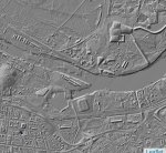
The LIDAR name is a combo of light and radar. The technique uses a laser on an aircraft to create an image of the ground. It comes in 2 'flavours', DSM (digital surface model) and DTM (digital terrain model). DSM shows the ground surface complete with buildings, trees (some), ..... etc. and DTM just shows the ground surface with all objects stripped away (even stuff like bridge decks disappear leaving only the approach works).
DSM

DTM

Edit: Meant to add that UK coverage can be found here LIDAR. There are a variety of resolutions 2m, 1m, 50cm & 25cm. Coverage is not complete with the higher resolutions being more limited.
DSM

DTM

Edit: Meant to add that UK coverage can be found here LIDAR. There are a variety of resolutions 2m, 1m, 50cm & 25cm. Coverage is not complete with the higher resolutions being more limited.
Last edited:
SmallTown
Well-known member
I hate astro physics! I jsut can never grasp it all. It's so complicatedNot entirely true, the gravitational pull off the sun would accelerate you way beyond 70 miles an hour and time would begin to slow down as you approached the Sun,but I get your point.
This is a good introductionI hate astro physics! I jsut can never grasp it all. It's so complicated

The Infinite Monkey Cage - Series 28 - Jo Brand's Quantum World - BBC Sounds
Brian Cox and Robin Ince are challenged by Jo Brand to explain Quantum physics.

