
You are using an out of date browser. It may not display this or other websites correctly.
You should upgrade or use an alternative browser.
You should upgrade or use an alternative browser.
River Leven joining point to the River Tees.
- Thread starter sambaDTR
- Start date
chickenrunner
Well-known member
Along the Teesdale Way from the Bluebell at Yarm looks the easiest (PROW). That will put you opposite the Leven entry point. Examination of Google maps satellite images suggests it is probably possible to sneak through from the Barwick side starting from a point near the junction of Roundhill and Blair avenues via the Round Hill mound. There is certainly one image of the confluence on Geograph taken from the Barwick side.
Ingleby_Flash
Well-known member
You can’t get to it from the IB side, the riverbank is blocked off so far along. But as said if you walk along the river bank from the Blue Bell you can see it from the opposite bank. Alternatively you can follow the Teasdale way from Dinsdale drive Egglesciffe down past the golf course and follow the river to Yarm, again you’ll see it on the opposite side.
xxlshirts_fit_all
Well-known member
Dont park at the Bluebell though... ;-)
chickenrunner
Well-known member
Hedge in front of the Round Hill mound does look pretty dense but I thought I'd spotted a gap further up the hill?You can’t get to it from the IB side, the riverbank is blocked off so far along. But as said if you walk along the river bank from the Blue Bell you can see it from the opposite bank. Alternatively you can follow the Teasdale way from Dinsdale drive Egglesciffe down past the golf course and follow the river to Yarm, again you’ll see it on the opposite side.
Someone obviously found a way through:

Corcaigh_the_Cat
Well-known member
Nip along Valley Drive until you come to a bungalow with a courtyard slightly below you on the left. If nobody is about pop through the garden and it's right in front of you.
Had you done it in the summer of 73 you would have had a chance to say hello to Eric McMordie on your way down, and to my dad and myself as you walked through the garden.
Had you done it in the summer of 73 you would have had a chance to say hello to Eric McMordie on your way down, and to my dad and myself as you walked through the garden.
Caesium137
Well-known member
What’s the easiest way to get to it?
Just buy this, you'd be pretty close...........
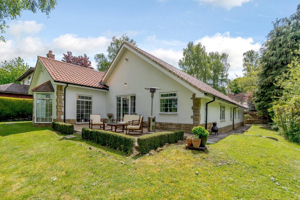
Check out this 4 bedroom bungalow for sale on Rightmove
4 bedroom bungalow for sale in Valley Drive, Yarm, Cleveland, TS15 for £875,000. Marketed by Strutt & Parker, Harrogate
chickenrunner
Well-known member
Go on, somebody has got to ask so it might as well be me ...................... what's the interest in the confluence of Tees and Leven?Doesn’t seem easy to get to then. Wonder if the “Teesside Princess” passes by it?
Edit: You didn't hoof a 'fly away' in at Low Green in Canny Yatton did you and you're waiting for it to come out at the Tees?
Last edited:
rob_fmttm
Administrator
A great way to visit the confluence is by the River Tees. I did it on a trip out last year. In COVID safe times getting on a boat from River Shack is a brilliant little river journey from Preston Park
rivershack
rivershack
sambaDTR
Well-known member
Chickenrunner, was looking at going for a trip to Great Ayton so looked at it on Google Earth. Realised that the River Leven that flows through it starts on the moors above Kildale then flows through Stokesley, Hutton Rudby then to the Tees. Thought it might be good to walk along part of it, while the golf courses are closed!
shelbeam90
Member
I agree with you Rob. This brings back memories. Me and my best mate Dave and Dave's dog Don ( I think he was with us) canoed as far as the bridge at the bottom of Leven Bank . Starting point was the bottom of Dave's garden which bordered the the Tees off Thornaby Green. And.... these were the days before the Barrage so it was tidal probably early 70's. Anyway we made it at high tide .stepped ashore, emptied the canoe of water (leaked like a sieve) and immediately set off back again as the water was running out. We barely made it back to the Tees..scraped the bottom a few times but made of plywood so ok! What an adventure! The river water in those days wasn't all that wholesome but had already began to improve.I remember swimming in the Tees near the old Barwick Quarry (is that still there?)without undue effect! We also made a small fortune retrieving Lowcocks lemonade bottles from the water as we progressed....three pennies was not to be sniffed at! I've still got the canoe hanging up in my garage but due to increase in girth I seriously doubt whether I'd fit in the thing! Ah happy days!
Ingleby_Flash
Well-known member
There is.enter from the estate in Eaglescliffe next to the golf course on Dinsdale drive, there may also be a public footpath from the farm in Egglescliffe,
chickenrunner
Well-known member
Tricky, but there are some rights of way along its length. Oddly I was up by the source on Warren Moor only a few weeks back. Leven factoid 1: Leven Mouth is where the Leven meets the Tame south west of Stokesley not where it meets the Tees. Leven factoid 2: Spitfire X4650 crashed into the bank of the river in 1940 (where the A19 viaduct is now) and was recovered in 1976 when water levels were very low. Restoration began in 1995 and it flew again in 2012 (cost circa £3M).Chickenrunner, was looking at going for a trip to Great Ayton so looked at it on Google Earth. Realised that the River Leven that flows through it starts on the moors above Kildale then flows through Stokesley, Hutton Rudby then to the Tees. Thought it might be good to walk along part of it, while the golf courses are closed!
Corcaigh_the_Cat
Well-known member
Just buy this, you'd be pretty close...........
Check out this 4 bedroom bungalow for sale on Rightmove
4 bedroom bungalow for sale in Valley Drive, Yarm, Cleveland, TS15 for £875,000. Marketed by Strutt & Parker, Harrogatewww.rightmove.co.uk
That's the one. Grafted on that for a while after doing my o levels. Looks really well established now. Happy days.
HarryVegas
Well-known member
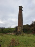
And here's a perspective from the Hidden Teesside site, including a photo of a rather scary looking uncovered, completely flooded shaft...Warren Moor Chimney - close to the source of the Leven.
Recently conserved with excavations and a big info sign.
Warren Moor Ironstone Mine - Hidden TeessideHidden Teesside (hidden-teesside.co.uk)
red_harrington
Well-known member
Go on, somebody has got to ask so it might as well be me ...................... what's the interest in the confluence of Tees and Leven?
I can't speak for anyone else but I used to live in the area for about 20 years and it was always something I wanted to see but never got round to doing it.
I must have walked many miles of the Leven in the Hutton Rudby, Crathorne, & Castle Levington areas but never got to see where it joined the Tees... it'll happen one day