Nunthorpe to Roseberry Topping

DearChicago

Well-known member
I’ve walked round the back of Nunthorpe School, over the bypass and past the building leading to the other side of the railway lines and wondered if you could continue to RT? I’ve looked on Google Earth and not sure if the tracks heading that way are private. Cheers.
 
I’ve walked round the back of Nunthorpe School, over the bypass and past the building leading to the other side of the railway lines and wondered if you could continue to RT? I’ve looked on Google Earth and not sure if the tracks heading that way are private. Cheers.
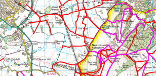
Yes you can, you would need an ordnance survey map to plot the route...field paths and through a couple of farms coming out at Newton Under Roseberry
 
Thats correct, you can walk on public footpaths all the way from Nunthorpe past the cricket field and to Newton under Roseberry, then on to RT. I have done the walk many times, sometimes on to Guisborough and bus back. They are all public footpaths on the OS map however as Nobby said they pass through farms and i know lots of public paths remain closed at present. will be wet too!
 
Probs better following Guisborough old railway line to Pinchinthorpe and back for a longer walk as homesick said the field paths are mud baths at the moment
 
There is a public footpath all the way.. passed through Newton under Roseberry.. via Blackthorn Gate.. I did it last year from Marton via Old Nunthorpe to cross the 172.. came back pretty much same way but closer to Whinstone View (public path, very grown over, via bend in Newton Rd at Cleveland Mountain Rescue base.. then up to Blackthorn Gate.. tracing path back.. 18km

Was a nice hike though.
 
Last edited:
I’ve walked round the back of Nunthorpe School, over the bypass and past the building leading to the other side of the railway lines and wondered if you could continue to RT? I’ve looked on Google Earth and not sure if the tracks heading that way are private. Cheers.
Go past the building and cross over the railway line. Continue up the track for a couple of hundred yards then take a left turn and go up the track running parallel with the railway line. Continue to the field gate and continue up the field path, again running parallel with the railway line until you come to a footpath crossing of the railway line. When you cross the railway you need to turn immediately right and follow the path parallel to the railway line for a while going through different fields. The path eventually veers off to the left towards a farm You go through the farm yard and keep following the path and not long after you will come to Newton under Roseberry.
 
Did it a few weeks ago and then thought I’d do Roseberry topping whilst I was there . That was a mistake as totally rammed on family and groups day out
 
Went from Marton today across the fields on rights of way via Blackthorn lodges (formerley Eastfield farm), to Newton under Roseberry, yellow arrows on the paths to keep you right and not too muddy at all, 👍🏃‍♂️
 
When I was 9, I walked from the Cross Keys to RT and then up onto Great Ayton - all my class mates did it as well. Thought nothing of it at the time, looking at it now it was quite a good achievement. We deserved our Suggetts ice cream that day.
 
Last edited:
If buying a map for this area, you will need OS 26 and as mentioned above, you get a code to download a digital version.

I always use a waterproof map. You can write on these and then wipe them off.
 
Back
Top